Click one of the topics below:
Understanding the feedback mechanisms between climate and biosphere is a vital key for the description of the past climate. As with climate, the vegetation can be simulated with numerical models, resulting in a variety of approaches. However, as there are no fundamental analytical equation systems to describe plant growth as a whole, the simulation of vegetationinvolves several problems.
One variable that has a pivotal role for feedback mechnamisms between eco system and atmosphere the evapo-transpiration. The land-surface exchanges heat and water with the atmsophere by evapo-transpiration.
In this project I developed a simple engery balance based parametrization approach to represent evapo-transpiration in the context of a global climate model. The results suggested that the newly developed approach is able to improve the representation of vegation, simulated with help of the BIOMEI model - a biogeographic equilibrium vegetation model.
The model was applied to climatic conditions over Northern Asia during the last interglacial period (130 ka - 115 ka BP). For palaeoclimatic reconstructions and simulations, thelast interglacial (LI), the most recent analogue for the currentinterglacial period with similar climatic conditions, is of special interest because the climate and vegetationdynamics during the LI period may provide important insights toenhance our understanding of the Earth’s system under the recentprogress of global warming.
Compared to the present day, the tree-line was located on average 4.0 further north during the peak of the warm period. Comparison of the modelled results withav ailable pollen-based reconstructions shows that the simulated and reconstructed results for the optimum of the interglacial period are consistent. With the start of the last glacial period the tree line finally retreats by roughly 10 degrees. The area occupied by forest in both simulations had declined by an average of 42%.
More details are available here: "Last interglacial vegetation in northern Asia: Model simulations and comparison with pollen-based reconstructions"
Weather and climate models produce large rainfall errors in tropical coastal regions where the rain is often shaped by land-sea interaction like sea-breeze circulation systems. These meso-scale circulation systems are a common feature in coastal areas in that can strongly influence the spatial and temporal organization clouds and hence rainfall in the tropics and sub-tropics. However, it has been difficult to quantify the contribution of land-sea interaction to the overall local rainfall.

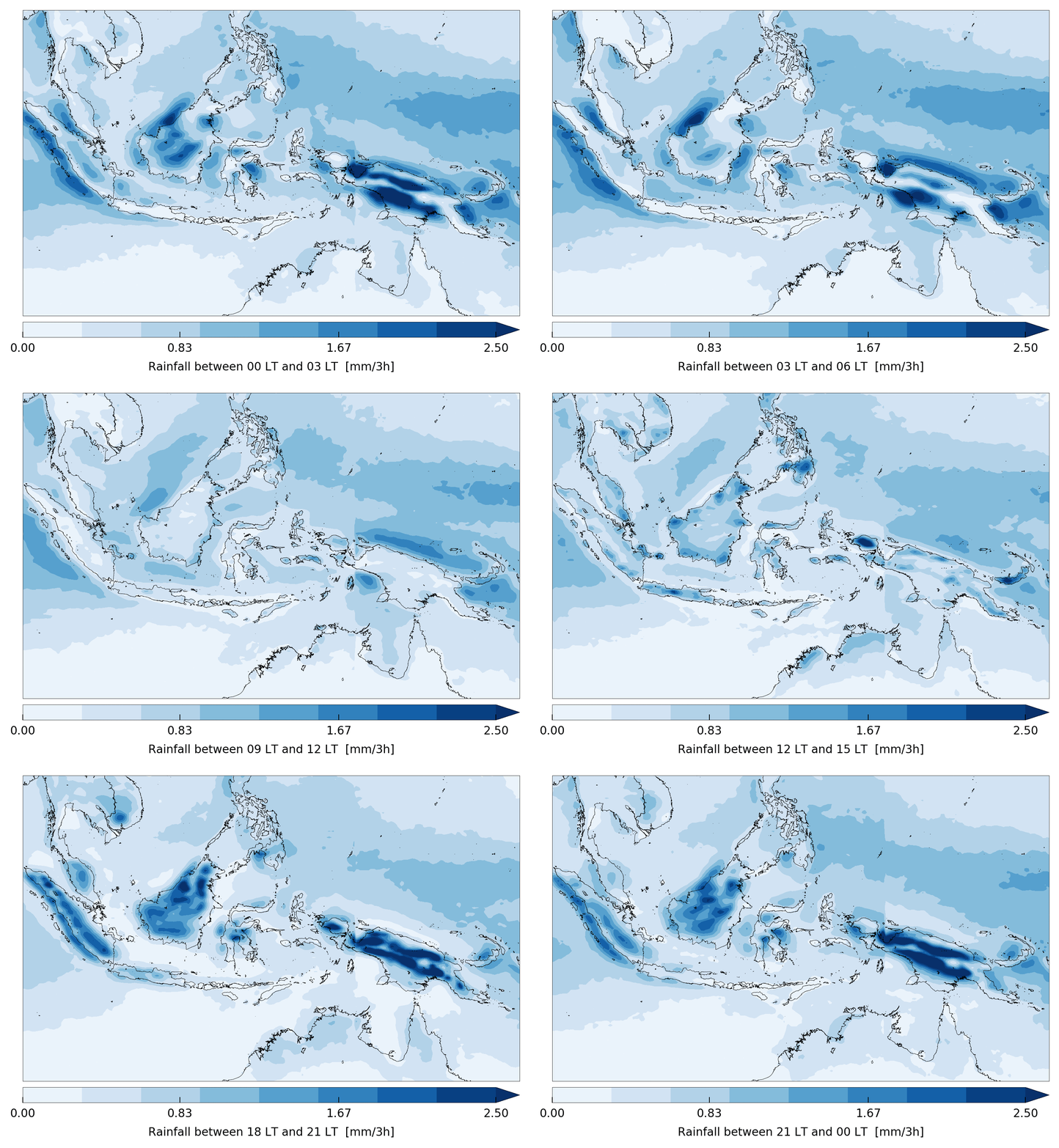
Fig.1 serves as an exmple for the complex spatio-temporal structure of rainfall, which serves as a good convection surrogate, in coastal areas.
The rainfall maxima during the day occurs over land (late afternoon to in the early evening). Rainfall peaks over the ocean occuring during the night to early morning.
Because rainfall near coastlines has a considerable amount of variability in diurnal and sub-diurnal frequencies that is poorly cpatured by numerical models it is
important to examine the characteristica of coastal rainfall, especially in the tropics.
In this project a pattern recognition algorithm to objectively identify precipitation patterns that are associated
with land-sea interaction is develped.
The algorithm takes satellite based rainfall estimates and applies state of the arte image processing techniques to find rainfall patterns that are aligned with the coastline and
and hence are associated with sea-breeze convergence that occur parallel to the coastlines.
The new dataset of coastal rainfall (rainfall picked up by the pattern recognition)
shows that about one third of the total rainfall that is recieved in coastal areas is associated by land-sea interactions (see also Fig.2).

An investigation of atmosphre in which the coastal rainfall occurs showed that once supported by meso-scale land-sea interactions the precipitation can occur in dier and more stable
large-scale atmospheric conditions. Sea-breeze systems could be seen a a mechanism that allows rainfall to form in large-scale conditdions that are less favorble. The sea-breeze moistens
and destabelizes the atmospheres on scales that are not resolved by a typical climate model. During sea-breeze conditions clouds will form in a rather narrow convergence line
that is associated with the breeze system. Once the clouds are from close together three mechanisms could be at work:
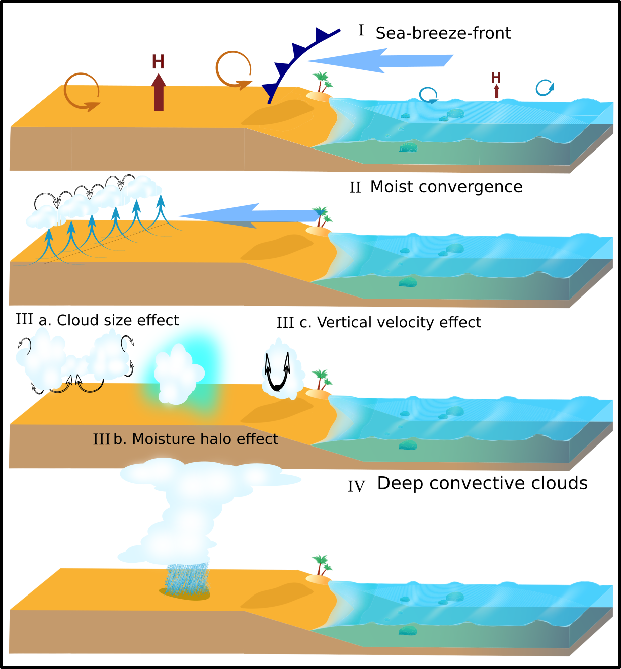
1) The clouds merge and grow bigger. Bigger clouds interact less with their environment in which they occur and can maintain longer in it.
2) The humidity advection by the sea-breeze favors the build up of moisture over land. New clouds will experience more humid conditions from the
humidity debris of the previous generations of clouds.
3) The sea-breeze convergence it self could make lifted parcels more buoyant and allow them to reach the freezing level where the latent heat release allows the to grow deep.
A schematic of the three mechanisms is given in Fig.3. This finding is important by the nature of bulk cumlus paramtetrizations that translate the large-scale state of the atmosphere
into convective processes and which do not take coastal effects into account.

Fig.3 - The three different mechanisms that could to the formation of coastal precipitation in drier and more stable large-scale atmospheric conditions.
Further info is available under:
Recent research has suggested that the overall dependence of convection near coasts on large-scale atmospheric conditions is weaker than over the open ocean or inland areas.
This is due to the fact that in coastal regions convection is often supported by meso-scale land-sea interactions and the topography of coastal areas.
As these effects are not resolved and not included in standard cumulus parametrization schemes, coastal convection is among the most poorly simulated phenomena in global models.
To outline a possible modeling approach of coastal convection for global climate models an idealized cloud model is developed and its ability to capture the main characteristics
of coastal convection is tested.
On the resolved scale climate models describe processes of ≈O(50 km) to ≈O(300 km). Cloud processes, especially those associated with tropical convection,
are usually acting on scales of ≈O(100 m) to ≈O(10 km). Stochastic models allow for a representation of different states within the same set of initial and boundary conditions.
The application of a model for convective clouds in a parametrization framework should meet several criteria. Different cloud types with various cloud top heights distribute moisture and
heat in the troposphere in different ways. Hence a parametrization should represent multiple clouds and types of them in one model grid box. Boualem Khouider (2014) presented a multi-state particle
interacting stochastic process to represent tropical convection. Based on observations of the cloud characteristics in the tropics the model applies a continuous-time Markov chain that describes the
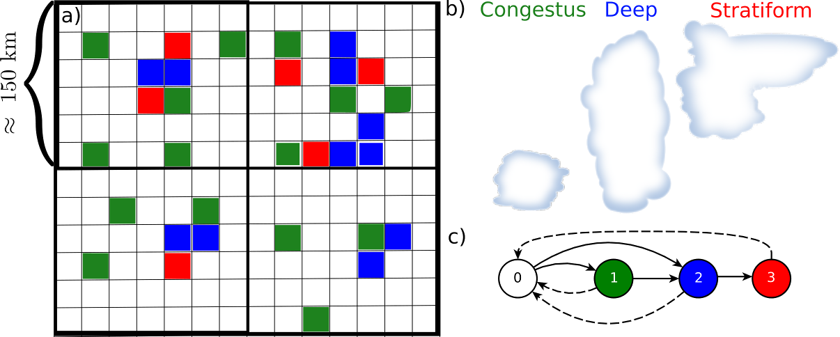
evolution of three different cloud types on a regular microscopic grid of N cells within a climate model grid box. Each cell can either be in clear sky (0) or
occupied by a congestus cumulus (1), deepcumulus (2) or cumulus cloud with a stratiform anvil (3, see also Figure Fg.1).
The model calculates transition rates Rkl from cloud type k to cloud type l.

Fig.1 - Schematic of the application of the Stochastic Multi Cloud Model. The model is applied on a mirco-scopic grid and applies a continous-time Markov chain (c) which describes brith-death and transition rates of three different cloudtypes in the tropcis (b,click to zoom).
To incorporate coastal effects the thermal heating contrast between land and ocean is taken into account. In a frist order approximation coastal effects, like land-sea-breeze circulation
systems are supposed to be present if the temerature difference between land and ocean is sufficent. The transition rates of the model are increased or decresed once coastal effects, as expressed
by the thermal heating contrrast: ΔT=Tland-Tocean.

Fig.2 - Simulated cloud area fractions of deep convective clouds in the coastal (solid black line) and the model version that is unaware of coastal effects (dashed black line). The pink line compares the radar based observations of convective pixels. The large-scale forcing for moisture and instability (scaled to be ∈ [0;2]) are plotted in green while the thermal heating contrast is given in organge. (click to zoom)

Fig.2 - Simulated cloud area fractions of deep convective clouds in the coastal (solid black line) and the model version that is unaware of coastal effects (dashed black line). The pink line compares the radar based observations of convective pixels. The large-scale forcing for moisture and instability (scaled to be ∈ [0;2]) are plotted in green while the thermal heating contrast is given in organge.
The newly developed model is tested by simulating cloud area fractions over Darwin (Australia) at the end of the wet season in April 1998. During the end of the wet season the conditions often
alternate between large-scale moist and instable condtions and relatively dry regimes that tend to favor coastal land-sea interaction. For simplicity the topography is assumed to be
a straigt coastline that devides the domain in land and ocean. Fig.2 shows the simulated cloud area fractions of the newly
developed coastal cloud model (solid black) and the model without the awareness of coastal land-sea interaction. It can not only be seen that the coastal cloud model is able reproduce a strong
diurnal cycle once coastal effects are deemed to be present. The model is also in better agreement with radar-based observations of convective pixels over the study domain. In the absence of coastal
processes, both modle version, coastal and non-coastal do not differ significantly.
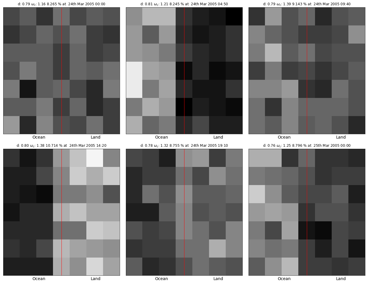
Fig.3 shows an animation of the simulated cloud area fractions of deep clouds:

Fig.3 - Animation of the simulated cloud area fractions in across the domain that is for simplicty divided into half land and half ocean. (White represents more clouds while dark areas are less cloudy)
The capability of this simple toy model to improve the spatio-temproal organization of clouds and convection in coastal tropical areas shows that this simple stochastic parametrization
approach has potential to improve the simulation of cumulus convection and rainfall in the coastal tropics within global numerical climate and weather prediction models that is otherwise
poorly captures by these models.
Single-column and cloud resolving models are very useful tools to test and evaluate physical parameterizations used in climate models. The model setup requires highly accurate forcing
information of the large-scale atmosphere that is usually assimilated with highresolution data from numerical weather prediction models. In this project I adopted the source code of an existing 4D Var
data assimilation method for compilation in an 64 bit environment. To simplify the usability of the assimilation process I also developed a framework that automatically pre- and post-processes the
assimilated data.
The software is available via GitHub-Pages: "https://antarcticrainforest.github.io/va_analysis/html/index.html"
In my most recent project I am trying to implement coastal effects into the Convection Scheme of the UK Met Office's weather forecasting and climte model, the Unified Model (UM).
At the moment the UM utilizes a so called bulk cumulus parametrization scheme where the large-scale state of the atmosphere is deterministically translateted into the cumulus convection.
In my previous work I was able to show that deep convective systems can occur in drier and less stable ambient atmospheric conditions once theses systems are supported by meso-scale land-sea interactions
that moisten and destabelizing the atmospheric conditions on scales typically not resolved by global models.
To inform the global model about the presence of meso-scale systems a simple filter algorithm is applied in the UM source code. The filter is purely based on large-scale atmospheric condtions and
consideres six criteria (see also Fig.1):

Fig.1 - Schematic of the filtering process that is applied in the UM to identify potential sea-breeze conditions, solely based on large-scale atmospheric pre-cursors. gx represents the value of the considered variable from the model (click to zoom).
Once coastal effects are deemed to be present, as calculated by the new coastal trigger function, lifted parcels will be made slightly more buoyant. This will incorporate the effects of meso-scale land-sea interactions that support moist convections in slightly drier and more stable atsmospheres, as shown in my previous work. I have generated a visualization of the UM code via doxygen which is available here UK Met Office Unified Model code visualization via doxygen


